![](/images/other/stat-length.png)
![Tocht Te voet Sogliano al Rubicone - IT-115 - Photo](https://media.geolcdn.com/t/1900/400/bc4d8283-3f09-443d-8cb6-415bbadc154a.jpeg&format=pjpeg&maxdim=2)
IT-115
SityTrail - itinéraires balisés pédestres
Tous les sentiers balisés d’Europe GUIDE+
![Lengte](/images/other/stat-length.png)
Lengte
29 km
![Max. hoogte](https://static1.geolcdn.com/siteimages/upload/files/1508320355ic_sort_altitude_max_24dp.png)
Max. hoogte
495 m
![Positief hoogteverschil](https://static1.geolcdn.com/siteimages/upload/files/1508320355ic_sort_den_pos_24dp.png)
Positief hoogteverschil
875 m
![Km-Effort](/images/other/stat-length.png)
Km-Effort
42 km
![Min. hoogte](https://static1.geolcdn.com/siteimages/upload/files/1508320355ic_sort_altitude_min_24dp.png)
Min. hoogte
86 m
![Negatief hoogteverschil](https://static1.geolcdn.com/siteimages/upload/files/1508320355ic_sort_den_neg_24dp.png)
Negatief hoogteverschil
1228 m
![Boucle](https://static1.geolcdn.com/siteimages/upload/files/16400158638029165_repeat_loop_refresh_sync_direction_icon.png)
Boucle
Neen
Markering
Datum van aanmaak :
2022-02-15 17:56:17.37
Laatste wijziging :
2022-03-01 22:13:26.799
![Te voet](https://static1.geolcdn.com/sitytour/trail-icons/100.png)
9h30
Moeilijkheid : Zeer moeilijk
![Scan deze QR-code om de tocht te openen in de SityTrail-applicatie](https://capi.geolives.com/qq0zvz2zws4bq2lad0pu/sitytour/trails/3123128/qr.png?size=200)
Gratisgps-wandelapplicatie
Over ons
Tocht Te voet van 29 km beschikbaar op Emilia-Romagna, Forlì-Cesena, Sogliano al Rubicone. Deze tocht wordt voorgesteld door SityTrail - itinéraires balisés pédestres.
Beschrijving
Symbol: 115 on white red flags
Plaatsbepaling
Land:
Italy
Regio :
Emilia-Romagna
Departement/Provincie :
Forlì-Cesena
Gemeente :
Sogliano al Rubicone
Locatie:
Unknown
Vertrek:(Dec)
Vertrek:(UTM)
282485 ; 4868039 (33T) N.
Opmerkingen
Wandeltochten in de omgeving
![Tocht Te voet Mercato Saraceno - IT-111 - Photo](https://media.geolcdn.com/t/375/260/f06967a0-c996-413c-8d8d-acabdadd49f0.jpeg&format=jpg&maxdim=2)
![Te voet Te voet](https://static1.geolcdn.com/sitytour/trail-icons/100.png)
IT-111
Te voet
Moeilijk
Mercato Saraceno,
Emilia-Romagna,
Forlì-Cesena,
Italy
![](/images/other/stat-length.png)
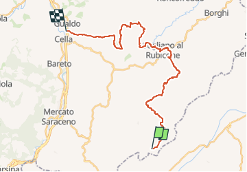
22 km | 33 km-effort
7h 32min
![](https://static1.geolcdn.com/siteimages/upload/files/16400158638029165_repeat_loop_refresh_sync_direction_icon.png)
Neen
![Tocht Te voet Sogliano al Rubicone - IT-015 - Photo](https://media.geolcdn.com/t/375/260/5c610cf1-f091-4893-835f-76dec7d4b40b.jpeg&format=jpg&maxdim=2)
![Te voet Te voet](https://static1.geolcdn.com/sitytour/trail-icons/100.png)
IT-015
Te voet
Gemakkelijk
Sogliano al Rubicone,
Emilia-Romagna,
Forlì-Cesena,
Italy
![](/images/other/stat-length.png)
4,1 km | 6 km-effort
1h 21min
![](https://static1.geolcdn.com/siteimages/upload/files/16400158638029165_repeat_loop_refresh_sync_direction_icon.png)
Neen
![Tocht Te voet Sogliano al Rubicone - IT-115H - Photo](https://media.geolcdn.com/t/375/260/ext.jpg?maxdim=2&url=https%3A%2F%2Fstatic1.geolcdn.com%2Fsiteimages%2Fupload%2Ffiles%2F1545311037marcheuse_200dpi.jpg)
![Te voet Te voet](https://static1.geolcdn.com/sitytour/trail-icons/100.png)
IT-115H
Te voet
Gemakkelijk
Sogliano al Rubicone,
Emilia-Romagna,
Forlì-Cesena,
Italy
![](/images/other/stat-length.png)
3,7 km | 6,2 km-effort
1h 25min
![](https://static1.geolcdn.com/siteimages/upload/files/16400158638029165_repeat_loop_refresh_sync_direction_icon.png)
Neen
![Tocht Te voet Mercato Saraceno - IT-111D - Photo](https://media.geolcdn.com/t/375/260/ext.jpg?maxdim=2&url=https%3A%2F%2Fstatic1.geolcdn.com%2Fsiteimages%2Fupload%2Ffiles%2F1545311037marcheuse_200dpi.jpg)
![Te voet Te voet](https://static1.geolcdn.com/sitytour/trail-icons/100.png)
IT-111D
Te voet
Gemakkelijk
Mercato Saraceno,
Emilia-Romagna,
Forlì-Cesena,
Italy
![](/images/other/stat-length.png)
3,3 km | 6 km-effort
1h 21min
![](https://static1.geolcdn.com/siteimages/upload/files/16400158638029165_repeat_loop_refresh_sync_direction_icon.png)
Neen
![Tocht Te voet Mercato Saraceno - IT-111AX - Photo](https://media.geolcdn.com/t/375/260/ext.jpg?maxdim=2&url=https%3A%2F%2Fstatic1.geolcdn.com%2Fsiteimages%2Fupload%2Ffiles%2F1545311037marcheuse_200dpi.jpg)
![Te voet Te voet](https://static1.geolcdn.com/sitytour/trail-icons/100.png)
IT-111AX
Te voet
Gemakkelijk
Mercato Saraceno,
Emilia-Romagna,
Forlì-Cesena,
Italy
![](/images/other/stat-length.png)
3,1 km | 5,5 km-effort
1h 15min
![](https://static1.geolcdn.com/siteimages/upload/files/16400158638029165_repeat_loop_refresh_sync_direction_icon.png)
Neen
![Tocht Mountainbike Novafeltria - m-italie-route-5 - Photo](https://media.geolcdn.com/t/375/260/ext.jpg?maxdim=2&url=https%3A%2F%2Fstatic1.geolcdn.com%2Fsiteimages%2Fupload%2Ffiles%2F1524743154velo.jpg)
![Mountainbike Mountainbike](https://static1.geolcdn.com/sitytour/trail-icons/202.png)
m-italie-route-5
Mountainbike
Heel gemakkelijk
Novafeltria,
Emilia-Romagna,
Rimini,
Italy
![](/images/other/stat-length.png)
40 km | 58 km-effort
Onbekend
![](https://static1.geolcdn.com/siteimages/upload/files/16400158638029165_repeat_loop_refresh_sync_direction_icon.png)
Ja
![Tocht Mountainbike Novafeltria - m-italie-route-4 - Photo](https://media.geolcdn.com/t/375/260/ext.jpg?maxdim=2&url=https%3A%2F%2Fstatic1.geolcdn.com%2Fsiteimages%2Fupload%2Ffiles%2F1524743154velo.jpg)
![Mountainbike Mountainbike](https://static1.geolcdn.com/sitytour/trail-icons/202.png)
m-italie-route-4
Mountainbike
Heel gemakkelijk
Novafeltria,
Emilia-Romagna,
Rimini,
Italy
![](/images/other/stat-length.png)
29 km | 43 km-effort
Onbekend
![](https://static1.geolcdn.com/siteimages/upload/files/16400158638029165_repeat_loop_refresh_sync_direction_icon.png)
Neen